Cañon de Carnué:
In 1763, the community of San Miguel de Laredo de Carnué was established at the mouth of Tijeras Canyon to serve as a protective settlement east of the Villa de Albuquerque by Governor Tomás Vélez Cachupín. The settlers at Carnué were described: “Ethnically, the settlers were a mixed lot, in addition to Spaniards, there were several coyotes, mixed bloods, and a handful of genízaros, the Hispanicized Indians who formed a kind of floating population in many New Mexico towns.”
Mission to Defend Villa de Albuquerque:
Similar to previously established genízaro settlements, the Carnué Land Grant was planned for settlement in a location that proved difficult to defend since the canyon is located at the entrance pass from the Plains into the middle Rio Grande valley, which was in the migration corridor of the Plains Apache, Kiowa, and Comanche tribes.
Raids on the Cañon de Carnué Settlers:
The Cañon de Carnué Settlers would be hit by many raids and in April 1771, some of the settlers would request to abandon the settlement. The residents of Carnué, in the request to the alcalde (mayor) of Albuquerque, stated that Carnué was far too dangerous to maintain and that they were poorly armed to defend the constant attack of the village.
Resettlement of the Carnué Land Grant after Raids:
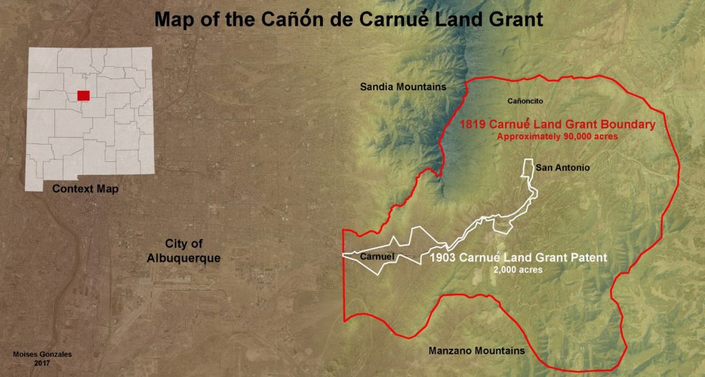
The resettlement of Carnué would not occur until 1819 when some of the descendants of the 1763 genízaro and coyote settlers petitioned to reestablish the settlement at Carnué along with additional landless residents of various villages in the Albuquerque area. The petitioners for the 1819 land grant were seeking opportunity as opposed to the servitude and peonage. During the re-settlement of the grant, two settlements were established, one in Carnuel at the mouth of the Tijeras Canyon and the other, San Antonio de Padua, located on the east slope of the Sandía Mountains.
Boundaries of the Cañon de Carnué Land Grant:
Described by Josef Marian de la Peña, secretary for Governor Facundo Melgares, as “the entrance of the Cañon de San Miguel de Carnué to the Tijera, the width of the canyon west to east and here South to North as far as the cross set up to the North of San Antonio” (SANM I, Reel 27, Frame 864-868). At San Antonio and Carnué, two defensible compact plazas were established measuring fifty varas (yards) square, and solares (plots) on the plaza were assigned. On February 5, 1819 suertes were assigned in Carnué along the Rito de Carnué (Carnué Creek) and on February 26 of that same year, suertes also were assigned at San Antonio de Padua. The land grant is organized today as a Community Land Grant under the laws of New Mexico. See the map below: